Category Archives: Land

Patience is the Key When Researching Family History

In Ireland researching my Moore family history from the 1600s I was reminded again that there are no shortcuts in discovering your genealogy and family history.

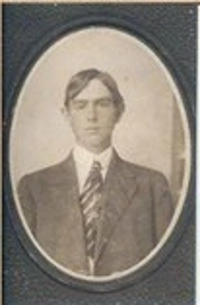
On my father’s side I am very fortunate to have an 850 page resource researched and written by a cousin, Timothy J. O’Rourke, in 1973.  “Maryland Catholics on the Frontier”, traces my Moore family lineage up the paternal line starting with Nicholas Moore born in Maryland in 1712. His father is listed as “possibly” William Moore.

This very complete and well documented history amazes me every time I go back to it. In 1973 there were no quick answers via the internet and digital images. The book represents years of on the ground research and document searches.

Since I started my quest to find more about my mother’s ancestors, Crittenden and West, I have also been able to add to my knowledge of the Moore family with online digitalized copies of birth and death certificates, marriage licenses and other documents verifying the research already done.

Our family’s oral history tells me that our ancestors immigrated to the United States in the Maryland area from Ireland in the 1600s. Not finding any definitive information online I got it into my head that a visit to Dublin (I was going to be in Europe already) and the genealogy department of the National Library of Ireland might provide some clues.

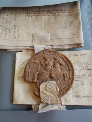
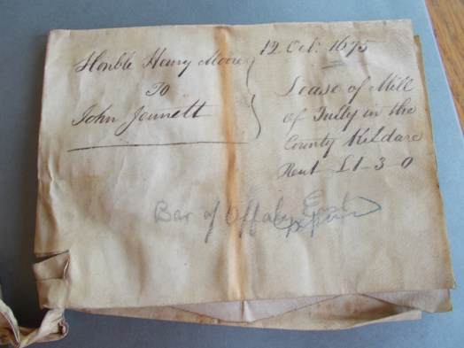
I was blown away by the antiquities available to research in their manuscripts sections, land documents from the 1500s and 16oos and even earlier.

1622 Mortgage Ireland.JPG

!5th and 16th Century deeds.JPG

However, I quickly realized that I was trying to make a very difficult leap from Maryland back to Ireland without enough information. I had thought maybe studying manuscripts with Irish Moore genealogies from the 1600s would provide me the clues that I needed. I did indeed find some genealogies with similar family naming patterns but none that mentioned family members moving to the United States in the correct time period.

I found documents with given and family names that could be a match to my family, but without enough detail to make a connection.

It this one of my ancestors - 1675.JPG

I met with a genealogist in at the National Library. She reminded me of what I really already knew. I was trying to skip a step. If I could not find what I needed about my Maryland ancestors online I needed to start in Maryland, on the ground, visiting libraries, court houses, churches and scouring documents in person.

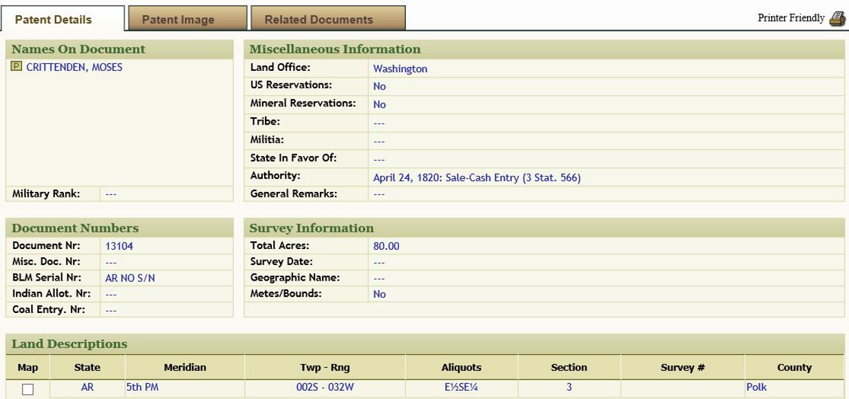
In my quests for more information in both my Crittenden and West lines I already knew that my key links, when I was stuck, were found by going to Oklahoma and Arkansas and spending weeks examining papers that I could only access in person. Hours, sometimes days, spent finding nothing only made the reward that much greater when I would find a key piece of the puzzle of my family’s history when I was least expecting. Often when I was on the last piece of paper after four to five hours in a library or court house I would find my great reward.

I am already scheduled to go to Oklahoma, Arkansas and Alabama in the fall of 2016 for the next step in Crittenden and West research. I now know that what I need to schedule next is a trip to Maryland to immerse myself in the Moore history of the 1600s and early 1700s.

I am confident that by remembering that I have to go back one step at a time, and that skipping a generation can lead to false assumptions, I will find the next missing piece in the link from Maryland to Ireland for my Moore ancestors.

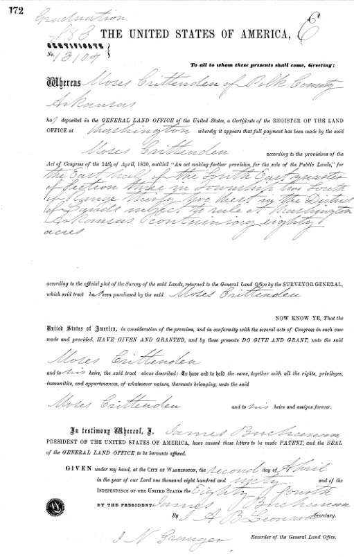
Once I find that link I will go back to Ireland and search once more through hand written Moore family trees and land documents, like the one below with its awesome seal. When I do, I hope to be able to piece together the story of my family in Ireland.

Look at this seal from the 1600s.JPG


4 Comments

Filed under Family connections, Journal, Land, Research

Cherokee Homesteaders in Polk County Arkansas

A search through the genealogy room at the Polk County Library in Mena Arkansas rewarded me with plat maps showing the exact locations of Cherokee Homesteaders in Polk County, Arkansas in the 1800s.  In addition to maps that showed the Township and Range of each homestead, there were maps that showed the topography of the land and maps that showed the county roads.

Township 2-S Range 32-W Polk County

Township 2-S Range 32-W Polk County


Polk County Rivers, Lakes and Streams

Polk County Rivers, Lakes and Streams

Polk County Homestead Roads

Polk County Homestead Roads

With maps in hand I started driving the county roads of Polk County.  Rather than head directly to the site of my great grandfather Moses Crittenden’s homestead which I had driven past that morning, I explored some of the rest of Township 2-S where extended family members had homesteaded.

I stopped and took photos of land owned by many of Moses’ Quinton, Winton and Phillips in-laws. My goal was to find a little road marked as Evans, off of Polk Rd 135.  It appeared to me that if I drove to the end of that road I would be almost due West of Moses’ land and North of the homestead of Elijah Phillips.   According to my plat map listing current owners, the land I was heading towards, owned by Levi N Hill in 1890, was now owned by the Evans family.

My goal in driving to the end of Evans Road was to have a clear view of the old Elijah Phillips homestead.  My grandmother’s half-brother Anthony Crittenden, son of the Phillips’ slave Emily Crittenden and my great grandfather Moses Crittenden, was most likely born on that land.  In two days I would be meeting Anthony’s grandson and great granddaughter in Warner, Oklahoma and wanted to be able to tell then that I had seen where Anthony was born.

When I reached the end of Polk Rd 135 I was rewarded by a small sign saying Evans Rd.  I headed down Evans Rd, a narrow gravel road with a high center and ditches on either side.  In my low riding compact rental, and with no cell phone coverage, I questioned the wisdom of continuing. However, I had not come that far to be put off by a little adventure, in spite of wondering how I would turn around when I got to the end of the road!

The road ended looking over beautiful farm land with trees in the distance.  I could tell from the compass in my rental car that the old Elijah Phillips’ homestead was straight ahead.  It was rewarding to be able to tell my Crittenden cousins a few days later that I looked out over the land where Emily Crittenden and her son Anthony had once lived.

To the left was a long dirt road leading up a hill with a new home at the top. I got out of my car to take photos of the land to the south and noticed a man standing on the side of the house looking down on me. Soon he was on a small tractor and heading my way.

I had brought a copy of the cover of the Family Maps of Polk County book with me.  I retrieved that from my car and greeted the man with, “You probably wonder what I am doing on your property.  My great grandfather owned the land to your east in the 1860s and I wanted to see it.”

Luckily the very welcoming current owner of the property was full of questions about how I found out the original owners of the land in the area.  I showed him my cover page (which he took a photo of with his phone so that he could do his own research at the library) and explained that I was researching my Cherokee heritage.  He was surprised to hear that any Cherokees had ever lived on this land.

I pulled out my homestead maps and pointed out all the names that I had highlighted on plats that I knew belonged to Cherokee family members.  He did not know that any Cherokees had ever lived in Polk County. He had grown up in the area and said it was never mentioned in Polk County history classes in school.  Given the denial that I had encountered throughout Arkansas of Cherokees having ever lived in the state, I was not surprised that he had never been taught this history.

He was full of questions, as was I.  When he saw the number of Quintons that I had highlighted on my plat maps he pointed to a mountain to the east of us and told me that it had always been known as Quinton Mountain and he never knew why (of course, that has been added to my list of things to research).

So far I have found very little information.  What I did find lists the location as Quentin Mountain, a different spelling from my ancestors.  I hope to find more information about how that mountain got its name and whether or not it has any connection to my family.

Next Mr. Evans told me about an old log cabin from the mid to late 1800s that sits next to his house.  He told me that I was welcome to drive up the driveway to his house and take a look at the cabin.

Log Cabin from 1800s on Neighboring Land

Log Cabin from 1800s on Neighboring Land

I was lucky to be greeted by the open and welcoming Mr. Evans.  He took me inside of the cabin built from hand hewn logs.  Later that day, after returning to my motel, I emailed my cousin John in Hulbert.  John commented that it was very likely that my great grandfather Moses had helped build that cabin or had at least visited there. It gave me chills to think that I may have stood in the same small house as Moses.

I so grateful to the owner of the land for being so welcoming to this trespasser. Viewing all of the land from the end of Evans road instead of the highway allowed me to really get a picture of what this land was like over a hundred years ago when my great grandfather and many other Cherokee families established a community here.


14 Comments

Filed under Cherokee History in Arkansas, Cherokee Roots, Journal, Land

Cherokee Polk County Arkansas Homesteads

Once I located and viewed my great grandfather Moses Crittenden’s homestead in Polk County Arkansas I was on a quest to find out more about Cherokee Polk County Arkansas homesteads.

I headed next to the Polk County Library in Mena, Arkansas. The library has a genealogy and history room with a good selection of reference material about the early days of Polk County.

Like elsewhere in Arkansas, I found little reference to Cherokee residents in the 1800s and early 1900s. This lack of recognition of the history of Cherokee settlers in Arkansas was a constant surprise on my research trip to Arkansas and will be the subject of an article in the future.

I did find a few documents related to deaths and births of members of Moses’ extended family in the historical section on vital statistics in the genealogy room.

After a few hours I was ready to leave when I noticed a spiral bound book in the early history of Polk County section of the library. Realizing that I had not pulled that book off of the shelf yet, I found something called the “Family Maps of Polk County, Arkansas”.

Family Maps of Polk County

Family Maps of Polk County

Looking at the cover I was assuming that inside was a history of the founding families of Polk County and where they resided. Given the lack of mention of Cherokee citizens in all the other reference materials I did not expect to find any information about my family members.

So I was overwhelmed with the wealth of information that I found in this unassuming appearing book. The book has detailed maps by section and range of all of the first homesteads purchased in Polk County, Arkansas. A search of the index by name found entries for Moses Crittenden and many of his extended family members.

Township 2-S Range 32-W.Polk

Township 2-S Range 32-W.Polk

Ends up that the cemetery I had stopped at that morning to take some photos was sitting on land once owned by Thomas Quinton, first cousin of Moses’ first wife, Edith Quinton.

Township 2-S Range 32-W.Polk.pg 2

Township 2-S Range 32-W.Polk.pg 2

I found over two dozen homesteads of members of my extended family, some of which are highlighted in just one of the many maps.

Anyone with Cherokee ancestors in Polk County Arkansas in the 1800s and early 1900s should try to get a copy of this book.

My next journal entry will be about my afternoon spent driving through the land of my ancestors, an afternoon that I hold close to my heart.

Note: March 13, 2019 – I just discovered that this book is available on Amazon.com. They have a paperback version or spiral bound (having used the book I would highly recommend spiral bound). They have both new and used.

1 Comment

Filed under Cherokee History in Arkansas, Cherokee Roots, Journal, Land

Discoveries in Polk County Arkansas

Last week I wrote about finding a copy of the land patent for the land my great grandfather, Moses Crittenden, purchased in 1860 in Polk County, Arkansas.

As soon as I held the description of the land in my hand I knew I would find my way to Arkansas and stand on that land.

On November 1, 2014 I fulfilled the promise made to myself and drove into Mena Arkansas, county city for Polk County. It was too late in the day to visit the court house or library. So, after a great meal at the Skyline Café in the center of town, I checked into my motel for a good night’s sleep in anticipation of a full day of researching starting early the next morning.

I was waiting on the court house steps the next morning anxious to find a map that matched the legal description on the land patent.

Description of Moses' Property

Description of Moses’ Property

The clerk was able to provide me with a map that had the current owner’s names written on a plat map for the appropriate township and range.  Using a map hanging on the wall of the county clerk’s office she pointed out some landmarks that would help me know when I reached the property.

Current Owner of Moses' Original Polk County Homestead

Current Owner of Moses’ Original Polk County Homestead

The clerk also provided me with a plat map showing the current owners of the neighboring land.

Current Owners of Neighboring Homestead Property

Current Owners of Neighboring Homestead Property

I wrote in the location of Moses original homestead and a few of his relatives on the plat maps and started my drive.  When I reached the curve in the road that I thought signified I was at Moses’ property I was very glad that I had the map with the current owner’s name.  The last name of the current owner is Huff.  At the entrance to the farm that I thought was on Moses’ old homestead was a large iron gate with a large “H” on it.  Obviously H for Huff. I was in the right place.

Cherokee Homestead Land in Arkansas

Cherokee Homestead Land in Arkansas

Coming later this week, the surprising discoveries I made later that day at the Polk County Library in Mena.

12 Comments

Filed under Cherokee History in Arkansas, Cherokee Roots, Journal, Land, Research

Tracing Cherokee Roots in Arkansas

My search for Cherokee Roots in Arkansas began with the 1850 and 1860 census data that showed my great grandfather Moses Crittenden residing in Freedom Township, Polk County, Arkansas.

Moses was born in Cherokee Nation Georgia around 1825 and moved to Arkansas with his father William some time before 1837.  I knew that he was living in Going Snake District in Cherokee Nation, Oklahoma Territory by 1875 when my grandmother was born.

I was determined to find out more about those years spent in Arkansas.  In the 1850 census Moses is listed as a farmer, and in 1860 as a merchant.  Many of his neighbors were in-laws of his sisters Lydia and Sydney Crittenden. One thing that caught my eye on the 1860 census was that Moses was shown to have real estate valued at $2000.

After much searching on the web I found my way to the Bureau of Land Management website where you could search land records by state going back to the 1800s.  I selected Arkansas state and Polk County, entered Moses Crittenden and hit the search button.  I hit pay dirt!

Search Results on Bureau of Land Management Web Site

Search Results on Bureau of Land Management Web Site

I clicked on the link highlighted in blue and was able to view a full description of the property.

Description of Moses' Property

Description of Moses’ Property

Next I clicked on the tab “Patent Image” and was able to view a printable PDF version of the land patent. I added that item to my cart and for $2.00 was sent a certified copy of the patent on parchment paper.

Using the description of the land and current land records I was able to determine that Moses’ land was near the current town of Mena, Arkansas. I knew that I had to see and stand on that land.

Next week – the discoveries I made on my trip to stand on my great grandfather’s land in Arkansas.


1 Comment

Filed under Cherokee Roots, Journal, Land, Research

Christmas and Family

Christmas is all about family for me. Tonight and tomorrow will be spent with my two boys, their spouses and my grandchildren.

This afternoon I am remembering Christmases past with family members who are no longer with me, my dad and my grandparents.

My Paternal Grandparents with Grandchildren 1951

My Paternal Grandparents with Grandchildren 1951

Me with my Dad as Santa Claus 1951

Me with my Dad as Santa Claus 1951

Maternal Grandmother Eliza Jane Critteden West wtih her Adult Children about 1952

Maternal Grandmother Eliza Jane Critteden West wtih her Adult Children about 1952

I am also thinking about my ancestors and wondering what their holidays were like. Last month I was blessed to stand on the beautiful land in Arkansas where my great grandfather Moses Crittenden, many of his relatives and other early Cherokee settlers, lived for much of the 19th century.

1850 Cherokee Land Freedom Polk County Arkansas Photo Taken 2014

1850 Cherokee Land Freedom Polk County Arkansas Photo Taken 2014

Standing looking out over where they lived I could feel the community and lives of my ancestors surrounding me. Today I can’t help but wonder about their family holiday traditions over almost 40 years on that land. I hope they can feel the love that I send out to them this day across time and space.

Leave a comment

Filed under Cherokee Roots, Family connections, Journal, Land

Cherokee Emigration Records 1829-1835

The Cherokee Emigration Records 1829-1835 were among the most valued finds on my family research trip to Oklahoma and Arkansas last month. For those of us whose Cherokee ancestors were early settlers who migrated to Arkansas before 1835 it contains a wealth of information.

To have some understanding of what the emigration records represent it is necessary to have some understanding of the 1828 Treaty with the Cherokee.

Under the Treaty with the Cherokee 1828 the U.S. Government made many promises. Two of those promises (see articles 2 and 3 of the treaty under resources below) were:
“Article 2…seven million acres of land in Arkansas…and a free and unmolested use of all the Country lying West..
Article 3… and to remove, immediately after the running of the Eastern line from the Arkansas River to the South-West corner of Missouri, all white persons from the West to the East of said line, and also all others, should there be any there, who may be unacceptable to the Cherokees, so that no obstacles arising out of the presence of a white population, or a population of any other sort, shall exist to annoy the Cherokees— and also to keep all such from the West of said line in future.”

As we all know, those U.S. promises meant nothing in the long run.

The government did fulfill a portion of the provisions laid out in Article 4.

“The United States moreover agree to appoint suitable persons whose duty it shall be, in conjunction with the Agent, to value all such improvements as the Cherokees may abandon in their removal from their present homes to the District of Country as ceded in the second Article of this agreement, and to pay for the same immediately after the assessment is made, and the amount ascertained.”

This brings us to the Cherokee Emigration Records 1829-1835. This document contains the names and property valuations of Cherokees who emigrated under the 1828 Treaty between 1829 and 1835.

I will use my great, great grandfather William Crittenden as an example of some of the information that can be found in these records.

One of the most important pieces of information for me is a better idea of when William moved from Georgia to Arkansas. I knew that as an early settler he had come sometime before 1837.

While the emigration records do not give me an exact date of his emigration, they do tell me the date that the valuation of his property was made, February 18, 1832. The valuations were made after the people listed had already moved. So, I know now that William and his immediate family left Georgia some time before 1832.

I have also been very curious about where William Crittenden lived in Georgia. The property valuation states that his property was on Petit’s Mill Creek. This will be especially meaningful to me when I travel to Georgia, I hope in the next few years.

Additional detail in the valuation of property:
1 house valued at $36.00
8 acres of high land valued at $5 per acre
2 acres of high land valued at $2 per acre
31/2 acres of low land valued at $6 acre
1 lot valued at $3
1 tub-still valued at $100
No apple or peach trees on the property
Total valuation of William Crittenden’s property in Georgia – $204

Some of the valuations have foot notes about the property. I was lucky to find one for William’s property.

“House but tolerable, as well as the land and fences; mill and fine stream, good mill works.”

I am not sure what “but tolerable” means, and it could well be an error in interpreting the handwritten notes from the original documents.

I have other relatives listed in the emigration rolls. None in as direct a line to me as my great, great grandfather William. However, I will eventually incorporate the information for them into my family’s history.

This is but one resource I found in my almost one month research trip to Oklahoma and Arkansas. As I make my way through my findings and organize them for entry into the family tree I will continue to share them with you.

I hope that some of you will find the Cherokee Emigration Records a helpful resource in your documentation of your Cherokee roots and family.

Resources for further research regarding Cherokee treaties and emigration
Treaty with the Western Cherokee, 1828
ARTICLE 2.
The United States agree to possess the Cherokees, and to guarantee it to them forever, and that guarantee is hereby solemnly pledged, of seven millions of acres of land, to be bounded as follows, viz: Commencing at that point on Arkansas River where the Eastern Choctaw boundary line strikes said River, and running thence with the Western line of Arkansas, as defined in the foregoing article, to the South-West corner of Missouri, and thence with the Western boundary line of Missouri till it crosses the waters of Neasho, generally called Grand River, thence due West to a point from which a due South course will strike the present North West corner of Arkansas Territory, thence continuing due South, on and with the present Western boundary line of the Territory to the main branch of Arkansas River, thence down said River to its junction with the Canadian River, and thence up and between the said Rivers Arkansas and Canadian, to a point at which a line running North and South from River to River, will give the aforesaid seven millions of acres. In addition to the seven millions of acres thus provided for, and bounded, the United States further guarantee to the Cherokee Nation a perpetual outlet, West, and a free and unmolested use of all the Country lying West of the Western boundary of the above described limits, and as far West as the sovereignty of the United States, and their right of soil extend.
ARTICLE 3.
The United States agree to have the lines of the above cession run without delay, say not later than the first of October next, and to remove, immediately after the running of the Eastern line from the Arkansas River to the South-West corner of Missouri, all white persons from the West to the East of said line, and also all others, should there be any there, who may be unacceptable to the Cherokees, so that no obstacles arising out of the presence of a white population, or a population of any other sort, shall exist to annoy the Cherokees— and also to keep all such from the West of said line in future.

Cherokee Emigration Records 1829-1835 – This book is a reprint of Senate Doc. #403, 24th Congress, 1st Session. It was compiled and indexed by Larry S. Watson with a 1990 copyright by HISTREE. It includes not only the valuation records of the land and improvements left in the east, but copies of the Treaty with the Cherokee 1817, Treaty with the Cherokee 1819, and Treaty with the Cherokee 1828. Reading the treaties helps to put the emigration records in context.

I have not been able to find an ebook or a hard copy of this book available for sale online. It is available at several libraries.

The Oklahoma Red Book Compiled by W. B. Richards, Corporation Record Clerk, Under the Supervision of Benjamin F. Harrison, Secretary of State, Oklahoma City, Oklahoma. This book covers much of the history of government history of public and private land in Oklahoma both before and after statehood. It can be downloaded from Amazon for Kindle for 99 cents.

Treaty with the Western Cherokee, 1828, May 6, 1828. | 7 Stat., 311. | Proclamation, May 28, 1828.

Cherokee Emigration Rolls 1817-1837National Archives database

1 Comment

Filed under Cherokee Roots, Journal, Land, Research

Accidental Discoveries

On my current genealogy trip to Oklahoma and Arkansas I am struck by the number of accidental discoveries that are enhancing my efforts at solving the mysteries of my ancestors.

When I came to Oklahoma on my first genealogy trip I was still missing so many basic details in my family’s lineage that the majority of the trip was about filling in the blank spots on the family tree; dates, middle names and first wives or husbands that I never knew existed.

This trip, while I am still filling in a few holes, my main goal is to discover the context and subtler details of my ancestors’ lives. No longer satisfied with knowing in what city and state they were born or lived, I want to know exactly what acreage they inhabited.

When they moved from Arkansas to Oklahoma, why did they make the move? Where did they go to school, to church? I find that my hunger for details is insatiable.

And I am finding that because I know so much more about my family that I am more in tune with leads to follow that might provide answers.

What has surprised me this trip is the casual decision made to say a few words to someone, or open a book that happens to be in front of me, that has led to me finding some missing details that I thought I might never find.

One of these accidental discoveries occurred two weeks ago in Wagoner, Oklahoma. It was a day that I had planned to do some exploring in another county with my second cousin, John. At the last minute he had some work obligations that could not be put off.

Rather than explore without him I decided to wrap up a few local details and reschedule with John for the next day.

One of the items on my list was to go to the Wagoner County Court House to see if I could find a follow-up document to some papers that I had found on my last trip regarding the sale of my grandmother’s Dawes Allotment land in Wagoner County.

While standing at the window in the County Clerk’s office waiting to talk with someone, I turned my head and noticed a very large and very old log book of some kind. It was at least two feet by three feet and four to six inches thick. There were lettered tabs on the right hand edge.

I opened the cover and it said something like Probates, 1907-1911. I flipped to “W” for West, my grandmother’s married name and saw nothing. Then I flipped to “C” for Crittenden my grandmother’s maiden name and the first two entries were for Moses Crittenden, her father, and Isaac Crittenden, her brother.

Isaac Crittenden

Isaac Crittenden

Next to their names were some dates and docket numbers. I wrote them down and when it was my turn to be waited on I asked if this book was just for display or did they have access to these particular old documents.

The answer was that the documents were in storage in another facility and that if I returned in a couple of days they would have copies of them for me. When I returned three days later I was told that they could not find the papers for Moses but that they had an 18 page document regarding the probate listed under Isaac Crittenden.

I knew Isaac did not die until many years after the date of this document so was very curious what this probate document was regarding.

What I found was that on April 1, 1907, shortly after Oklahoma became a state, Margaret Crittenden, Isaac’s mother, had filed to be Isaac’s, then still a minor, guardian over the possessions that he had inherited from his father, Moses, in 1999 and over the Dawes land that Isaac had been allotted.

Included in this document was a complete legal description of Isaac’s allotment land. At the end of this legal description was the answer to a question I had been asking for the past five years.

I knew from census data that my grandmother lived with her mother outside of Wagoner in Township 16 in 1900 and probably for some time before that. I had descriptions of my grandmother’s, and her brother Isaac’s, Dawes allotment land in Township 16. On my last trip I had gone and stood on that land and wondered if any of the allotment land that they received was the land on which they had lived.

And now, this amazing accidental discovery answered a question to which I thought I would never know the answer. At the end of the description of Isaac’s allotment land in the probate papers is the following sentence.

“All 90 acres being Cherokee land with valuable buildings thereon being part of the old ‘M.Crittenden Homestead’. Estimated that 25 acres are in cultivation. This land is part prairie and part timber.

I could have stood at some other window in the clerk’s office. One that did not have an old probate log sitting behind it. I could have not turned around and been curious enough to open it. This accidental discovery could so easily have never been made. But it was. And now I know exactly where my grandmother lived from the late 1890s until she married my grandfather in 1903.

Every day of this trip I feel a little closer to my grandmother and to the amazing life that she lead.

Leave a comment

Filed under Cherokee Roots, Dawes Allotment, Journal, Land, Research

Tracing my Great Grandfather Moses Crittenden in Cherokee Nation West

The journey of the early settlers to Cherokee Nation West is a complicated one.  My great grandfather Moses Crittenden was born in Cherokee Nation East Georgia in 1825. The next record that I have found for him is the 1850 census that shows him living in Freedom Township Polk County Arkansas at age 25 with his wife Eda Quniton, age 22. I believe Eda (Edith) is Moses’ niece, his sister Lydia’s daughter.

I am on a constant quest for records that will help me determine exactly when Moses moved from Georgia to Arkansas. His father William Crittenden is shown on the 1835 census as living in Talking Rock Creek, GA.  Both Moses and his father William are listed on the Old Settler Roll of 1851

In the 1850 census in Freedom, Polk County AR there are six Quinton family households listed on the same census record with the Moses Crittenden household.  Moses is listed as a farmer.

In the 1860 census in Freedom AR the Moses Crittenden household is surrounded by six Quinton family households. Moses’ father William, then 80, is living with Moses.  Two important facts are found on the 1860 census.  Moses is now listed as a merchant and in the column under Value Real Estate is the figure 2000.

In November 2013, now knowing that Moses owned real estate in Arkansas, I started a search to try to find information on land owned by Moses Crittenden.  I accessed the following sites which eventually led me to the Bureau of Land Management (BLM) Federal Land Record site.

http://www.ark-ives.com/documenting/

http://www.arkansasgenealogy.com/

http://searches.rootsweb.ancestry.com/cgi-bin/arkland/arkland.pl

http://www.glorecords.blm.gov/

The Bureau of Land Management (BLM) Federal Land Record site includes a searchable database where I found a copy of Moses’ land patent signed by President James Buchanan.  I also found two patents for land owned by James Quinton.

http://www.glorecords.blm.gov/search/default.aspx

Moses Crittenden Search Result BLM Land Patents

Moses Crittenden Search Result BLM Land Patents

I sent for a hard copy of the document for under $5.00 I received a printed copy on parchment paper along with a copy of the plat map.

Copy of Moses Land Patent

Copy of Moses Land Patent

My next genealogy research trip in November 2014 will take me back to Oklahoma and then on to Arkansas.  Finding the exact location of Moses’ land means that I will be able to search local archives, libraries and museums for additional information on my great grandfather’s time in Arkansas.  I will also be able to go to the site of his land, surrounded by the echoes of my great grandfather Moses Crittenden and his extended family.


5 Comments

Filed under Journal, Land, Research

Online Resources for Getting from Dawes Roll# to Allotment Plat Map

Dawes Final Rolls

The first step in the process of identifying Dawes land allotments is to have the Dawes Roll # for the person whose land you are trying to identify. If you do not have the number, go to http://www.okhistory.org/research/dawes and fill in as many of the blanks as you can and you will find the following information.

Name, Age, Sex, Blood, Card No., Tribe, Roll No.

The Card No. is the same for each member of a household. Each individual in the household will have a different Roll No.

Dawes Enrollment Packets

You can find the packets at http://www.fold3.com/title_70/dawes_packets/. You must be a member to access the images.

You can also access the files on https://familysearch.org/search/collection/1852353. You will need to sign up to use this site but it is free.

Search by name. Having the roll number will help you to identify that you have the right file as there are many duplicate names on the Dawes Rolls.

Each piece of paper in the packet has been scanned. There is a lot of interesting information in the Dawes Enrollment Packets. In addition to the application forms there are often transcripts of interviews with applicants and other family members or friends.

Allotment Applications

After the final Dawes Roll was published, each individual had to complete another application to apply for their land allotment. The applications can be found in Oklahoma Applications for Allotment, Five Civilized Tribes, 1899-1907 at https://familysearch.org/search/collection/1390101.

On Aug 1, 2014 they were indexing this site to include some previously missing applications that have been newly digitalized. Try again if you cannot access the records the first time. I will keep checking the site and update this information when the site is functioning again. You will need a Dawes Roll number to use this collection. You cannot search by name.

Use the land description information from these applications to search for your allotment plat map. The allotment applications contain the legal land description of the final allotments to each person who was approved to receive an allotment.

Allotment Maps

Allotment Maps can be found at http://www.okhistory.org/index. They are a little tricky to get to, so follow the directions exactly.

On the home page click on “Research Center”. From the dropdown menu choose “Maps”.

In left-hand column at the bottom of the Maps page click “Search Catalog”.

On the Search Catalog page click “Archives Catalog”.

You will see a Search Dialog box. Under that box in small letters it says “Core Collections”. Click on the small arrow to the left.

An alphabetized list of core collection will appear next. Halfway down the alphabetized list click “Indian Archives”. The next page is slow to load so be patient.

On the Indian Archives page in the left hand column click on the plus sign next to the last entry, “Maps”. Do not click on the word Maps, click the plus sign.

Next click the plus sign next to Cherokee Nation maps (or whichever tribe is appropriate).

You will see a list of maps that are in PDF form. The plat allotment maps are images #69 – #305 in the Cherokee Nation section. They are not numbered so you have to count your way down the list to get to that general area. You will know you are in the right spot when you start seeing maps listed by Township and Range.

Click on the description of the correct Township and Range to see a PDF of the map with allotment names. You can then download and save the map to your computer.

Allotment maps are organized by Township and Range. Each map shows the sections for that range and with a little practice you can find NE4 of NW4 of SE4 of Section 11, Township XXN, Range XXE.

Each of the maps has the name and roll number of the person allotted each plot of land written by hand on the plot. In some cases, including one of my grandmother’s plots, the land was awarded after the maps were completed. If you follow the description you have from the Land Allotment package and do not see the name you are looking for you will usually find a little blank square where you can then write in the name of your relative on a hard copy of the map.

In Conclusion

It is getting easier and easier to accomplish these tasks.  When I first started my research not all Dawes Application Packets were digitalized and online.  Every month I would go to the site again and enter my grandmother’s information and hope her packet would be there.  For over a year I always got a message saying that those records were in the process of being digitalized.  And then one day, success!  Genealogy research involves a lot of patience and persistence which, in most cases, eventually results in finding the information that you are seeking.


Leave a comment

Filed under Dawes Allotment, Journal, Land