A search through the genealogy room at the Polk County Library in Mena Arkansas rewarded me with plat maps showing the exact locations of Cherokee Homesteaders in Polk County, Arkansas in the 1800s. In addition to maps that showed the Township and Range of each homestead, there were maps that showed the topography of the land and maps that showed the county roads.

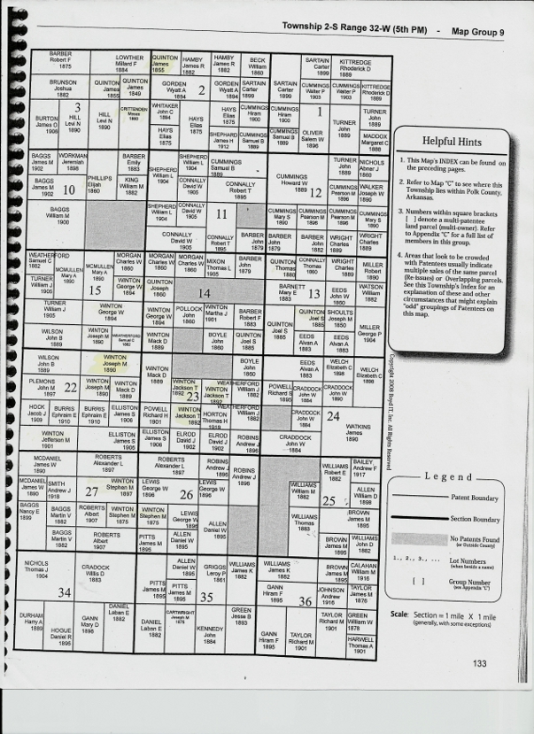
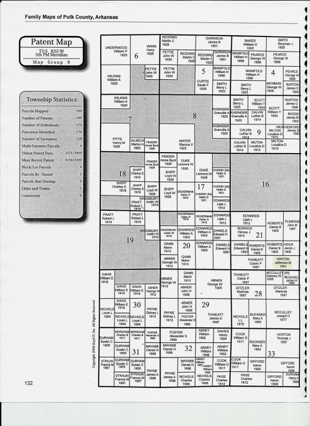
Township 2-S Range 32-W Polk County

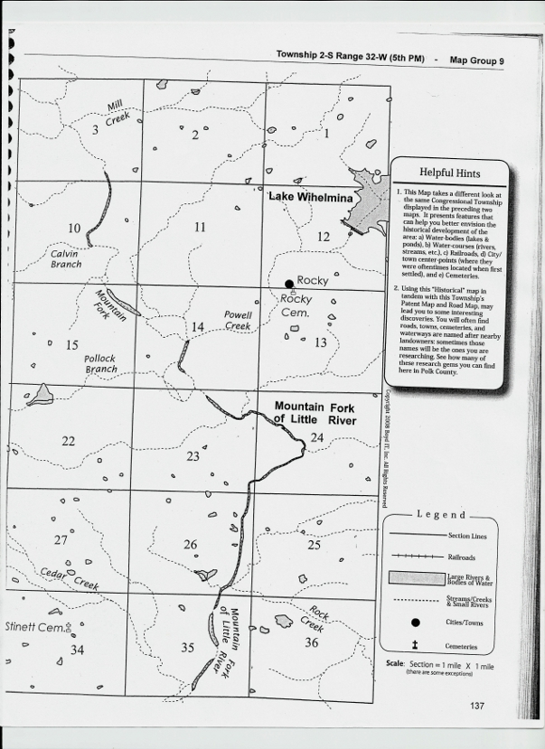
Polk County Rivers, Lakes and Streams

Polk County Homestead Roads
With maps in hand I started driving the county roads of Polk County. Rather than head directly to the site of my great grandfather Moses Crittenden’s homestead which I had driven past that morning, I explored some of the rest of Township 2-S where extended family members had homesteaded.
I stopped and took photos of land owned by many of Moses’ Quinton, Winton and Phillips in-laws. My goal was to find a little road marked as Evans, off of Polk Rd 135. It appeared to me that if I drove to the end of that road I would be almost due West of Moses’ land and North of the homestead of Elijah Phillips. According to my plat map listing current owners, the land I was heading towards, owned by Levi N Hill in 1890, was now owned by the Evans family.
My goal in driving to the end of Evans Road was to have a clear view of the old Elijah Phillips homestead. My grandmother’s half-brother Anthony Crittenden, son of the Phillips’ slave Emily Crittenden and my great grandfather Moses Crittenden, was most likely born on that land. In two days I would be meeting Anthony’s grandson and great granddaughter in Warner, Oklahoma and wanted to be able to tell then that I had seen where Anthony was born.
When I reached the end of Polk Rd 135 I was rewarded by a small sign saying Evans Rd. I headed down Evans Rd, a narrow gravel road with a high center and ditches on either side. In my low riding compact rental, and with no cell phone coverage, I questioned the wisdom of continuing. However, I had not come that far to be put off by a little adventure, in spite of wondering how I would turn around when I got to the end of the road!
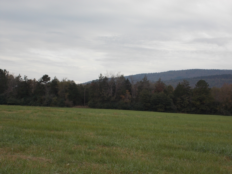
The road ended looking over beautiful farm land with trees in the distance. I could tell from the compass in my rental car that the old Elijah Phillips’ homestead was straight ahead. It was rewarding to be able to tell my Crittenden cousins a few days later that I looked out over the land where Emily Crittenden and her son Anthony had once lived.
To the left was a long dirt road leading up a hill with a new home at the top. I got out of my car to take photos of the land to the south and noticed a man standing on the side of the house looking down on me. Soon he was on a small tractor and heading my way.
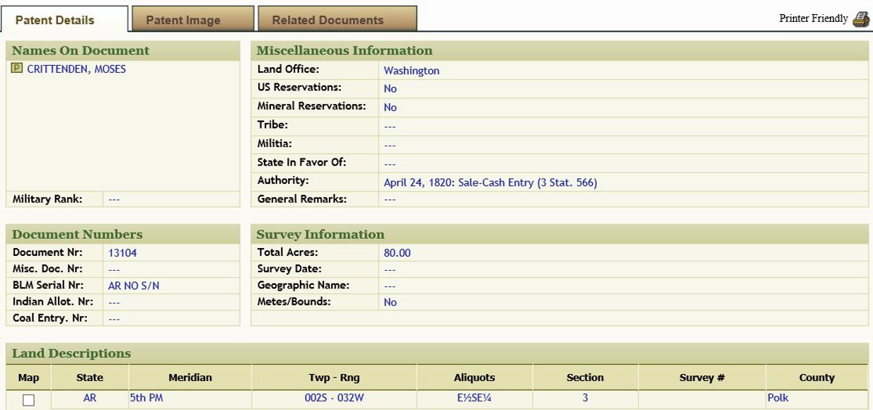
I had brought a copy of the cover of the Family Maps of Polk County book with me. I retrieved that from my car and greeted the man with, “You probably wonder what I am doing on your property. My great grandfather owned the land to your east in the 1860s and I wanted to see it.”
Luckily the very welcoming current owner of the property was full of questions about how I found out the original owners of the land in the area. I showed him my cover page (which he took a photo of with his phone so that he could do his own research at the library) and explained that I was researching my Cherokee heritage. He was surprised to hear that any Cherokees had ever lived on this land.
I pulled out my homestead maps and pointed out all the names that I had highlighted on plats that I knew belonged to Cherokee family members. He did not know that any Cherokees had ever lived in Polk County. He had grown up in the area and said it was never mentioned in Polk County history classes in school. Given the denial that I had encountered throughout Arkansas of Cherokees having ever lived in the state, I was not surprised that he had never been taught this history.
He was full of questions, as was I. When he saw the number of Quintons that I had highlighted on my plat maps he pointed to a mountain to the east of us and told me that it had always been known as Quinton Mountain and he never knew why (of course, that has been added to my list of things to research).
So far I have found very little information. What I did find lists the location as Quentin Mountain, a different spelling from my ancestors. I hope to find more information about how that mountain got its name and whether or not it has any connection to my family.
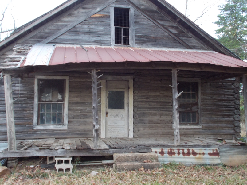
Next Mr. Evans told me about an old log cabin from the mid to late 1800s that sits next to his house. He told me that I was welcome to drive up the driveway to his house and take a look at the cabin.

Log Cabin from 1800s on Neighboring Land
I was lucky to be greeted by the open and welcoming Mr. Evans. He took me inside of the cabin built from hand hewn logs. Later that day, after returning to my motel, I emailed my cousin John in Hulbert. John commented that it was very likely that my great grandfather Moses had helped build that cabin or had at least visited there. It gave me chills to think that I may have stood in the same small house as Moses.
I so grateful to the owner of the land for being so welcoming to this trespasser. Viewing all of the land from the end of Evans road instead of the highway allowed me to really get a picture of what this land was like over a hundred years ago when my great grandfather and many other Cherokee families established a community here.